Project Blog
Medieval Maps: The Gough Map
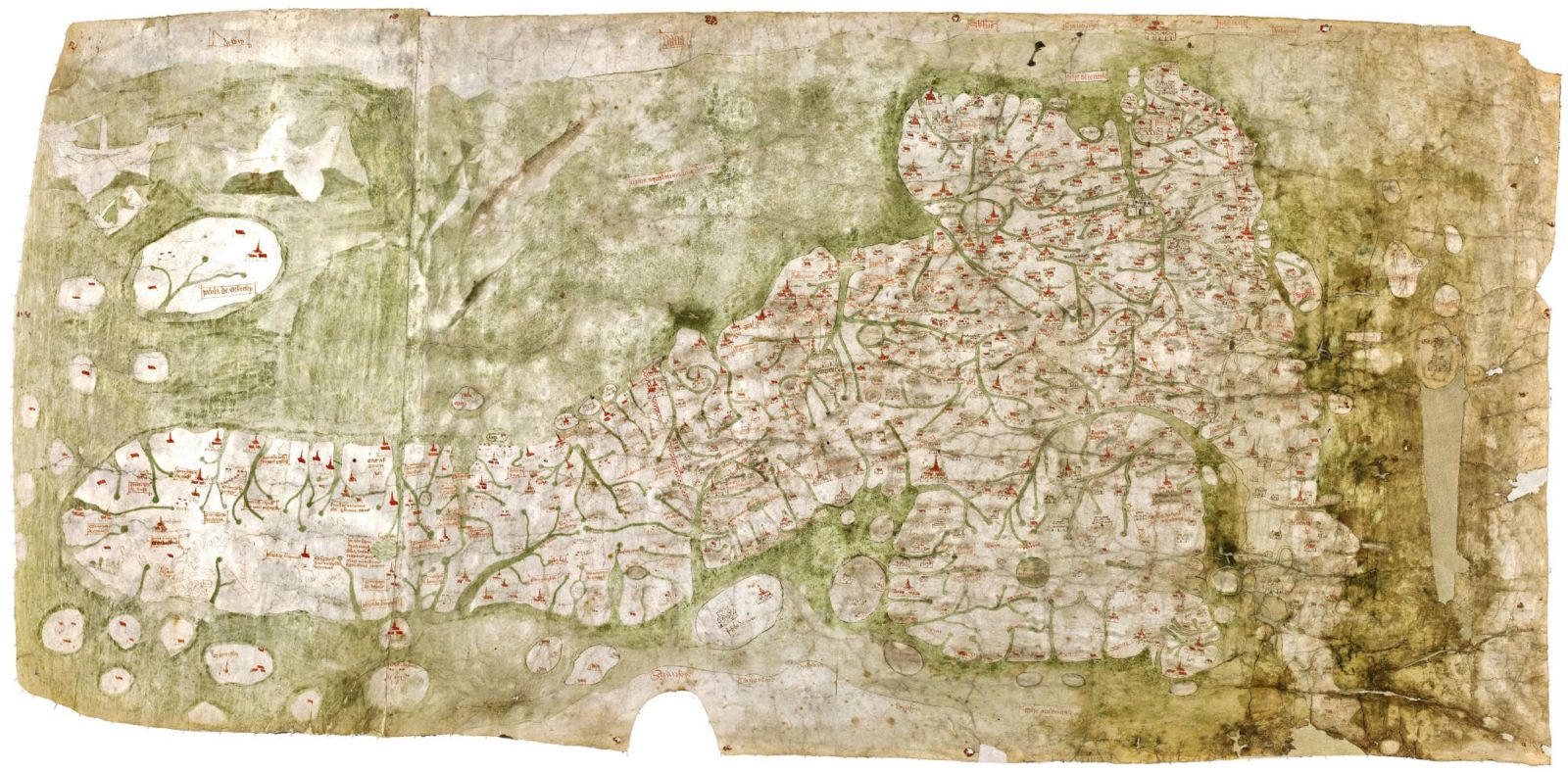
Whilst the most famous medieval maps are the T-O type mappae mundi, there are other types of map surviving from the Middle Ages. A fascinating example is the Gough Map, preserved in the Bodleian Library, University of Oxford (shelfmark MS. Gough Gen. Top. 16). This map depicts the whole of the island of Britain. Like the T-O mappae mundi, this map is oriented to the east, but unlike these world maps, it contains a wealth of detailed contemporary information, rather than a diachronic view into the history of the world. It is incredibly detailed, showing 654 inhabited centres, including monasteries as well as towns (Lilley et al, ‘Mapping the Realm’). While for a long time the maps has remained a mystery, recent research, from the project ‘Linguistic Geographies: The Gough Map of Great Britain and its Making‘ succeeded in dating it to the second half of the fourteenth century, ca. 1370.

The Gough Map of the British Isles, 14th century. © Bodleian Library, University of Oxford; retrieved from: https://www.bl.uk/collection-items/the-gough-map (13 October 2018); usage terms Public Domain
The image above is a Public Domain image provided by the British Library, but the Linguistic Geographies project provides some fantastic resources to explore, which include a high-quality scanned image (here: http://www.goughmap.org/map/) with a very powerful zoom function, as well as information about the map, and a number of in-depth studies, all available on their website. One of the most exciting possibilities that this digitalisation project offers, is that is possible to search their digital version of the map using not only medieval but also contemporary place-names, a demonstration of the highly detailed and accurate nature of this medieval map.
The Gough Map is also a great example of the importance of conservation, as the article on Bodleian Library website demonstrates.
The literature on the Gough Map is vast, but a good place to start is Nick Millea, et al., The Gough Map the Earliest Road Map of Great Britain? (Bodleian Library, 2007).
In connection to the two digitalisation projects undertaken in this century, see (2009) ‘Mapping the Realm: A New Look at the Gough Map of Britain (c.1360)’, Imago Mundi, 61:1, 1-28, DOI: 10.1080/03085690802456228 and also the article ‘Re-digitalization of the Gough Map‘ on the Gough Map project website. Most recent results are in (2017) ‘New Light on the Medieval Gough Map of Britain’, Imago Mundi, 69:1, 1-36, DOI: 10.1080/03085694.2017.1242838
Post by Natalia Petrovskaia