Project Blog

UCMS Guest Lecture
On Thursday 26 November, the first Utrecht Centre for Medieval Studies (UCMS) guest lecture of the academic year took place on Zoom. The lecture was by Dr Seb Falk, University of Cambridge, and was on the topic of “The Light Ages: A Medieval Journey of Discovery”. An abstract for the talk can be seen here….
Read moreUtrecht online workshop on ancient and medieval city walls
Today, attending the online workshop on ancient and medieval city walls, “Muros et Moenia: City Walls, Urban Boundaries, and the Articulation of the City in the First Millennium CE” organised at Utrecht University. https://citizenshipdiscourses.sites.uu.nl/international-digital-workshop-seminar-muros-et-moenia/
Read moreSome online resources on Maps and Geography
There has been much interest in the development of geographical perceptions and in the history of cartography in recent years (arguably, not only in recent years, but steadily throughout the history of the discipline). A large number of freely available resources and discussions can be found online. In addition to the resources offered, for instance,…
Read more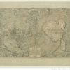
Maps of Europe at the BnF
This year we are more reliant than ever on digital resources not only for research, but for recreation (a growing number or virtual museums and virtual exhibitions have made this possible). Whilst not strictly speaking an exhibition, the Bibliothèque nationale de France has a fantastic site dedicated specifically to maps of Europe. There is also…
Read more
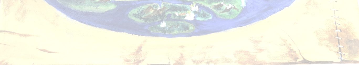
Matters of the Heart
It is February the 14th, and heart-shaped things seem to be everywhere. In keeping with the theme, I would like to talk about heart-shaped maps. While heart-shaped chocolates and decorations are omnipresent on Valentines day, heart-shaped maps are less often seen. Yet there are quite a few surviving from the sixteenth-century, when the cordiform (=heart-shaped)…
Read more
Honorius Augustodunensis, his “Elucidarium”
Honorius Augustodunensis wrote a large number of works in addition to the Imago mundi, which forms the center of the present project. Of these, the most influential and best-studied is the Elucidarium. The Elucidarium is an enclyclopaedic work similar to the Imago mundi. It was also translated into many languages and found immense popularity. However, unlike the latter,…
Read moreOld Maps at the University Library
The Utrecht University Library Special Collections division has an impressive collection of maps. Digitalized maps can be accessed online, through the library’s geographic search engine . The University Library’s extensive digitalization initiative is described in this video: The digitalized maps are made accessible in the Georeferencer tool (a very accessible and useful explanation is provided…
Read more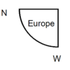
More Medieval Maps
A fantastic introduction to medieval maps in general by P. D. A. Harvey is available on the British Library website in an updated version of an article first published in 1991. Also on the British Library website, another article by P. D. A. Harvey addresses the question of production and purpose of medieval local maps….
Read moreWhat’s in a name? Honorius Augustodunensis
Honorius Augustodunensis, author of the Imago mundi (and several other works, of which the most famous was perhaps the Elucidarium), is an author as elusive and mysterious as he was prolific. This is particularly aptly illustrated by the variety of names under which he is known. Even in contemporary scholarship there are several different ways of referring…
Read more
Utrecht Centre for Medieval Studies Annual Colloquium (2019)
On Thursday, June 13, 2019, the Utrecht Centre for Medieval Studies held its 6th Annual Colloquium. The Colloquium, which took place at Drift from 13:00 until 18:00 presented a varied and exciting programme of talks by students, researchers, and alumni, with poster presentations by current MA students, and a ‘book market’ showcasing recent publications by…
Read more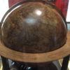
More Globes
The earliest European globe, made by Martin Beheim in 1492 (mentioned in our previous blog post “Globes and Celestial Spheres”), precedes the discovery of the Americas and shows the world as it had been known throughout the Middle Ages. The globe can now be seen digitally, in 3-D at https://c.bnf.fr/CnE. It is also currently on show…
Read moreMedieval ‘Encyclopedias’
In the course of this project, the question of the genre of Honorius Augustodunensis’s Imago mundi often arose. Can we describe this text as an “encyclopedia” if the term was not used when this text was composed? Can a medieval text be termed an “encyclopedia” at all? The question of terminology has occupied scholars studying medieval scholarly…
Read moreThe creation of a digital database
One of the more visual results of the research done in the Defining Europe project is a manuscript database containing as many manuscripts as possible of Honorius Augustodunensis’ Imago Mundi and its translations into the vernacular. This database will contain a corpus of over 350 manuscripts containing this text and show how this text has…
Read morePiece by piece
Many of the copies of the Imago mundi text and its translations that we have catalogued for our database are in a fragmentary state. Medieval manuscript fragments are an important resource that has attracted increasing scholarly attention in recent years. Fragments can tell us much about the richness of medieval manuscript cultures. An extraordinary case are…
Read more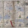
Medieval Maps: the Catalan Atlas
The Bibliothèque nationale de France manuscript Esp.30, better known as the ‘Catalan Atlas’ is one of the more spectacular adaptations of the Imago mundi by Honorius Augustodunensis which we study in the present project. The beautiful Atlas, attributed to one Abraham Cresques of Mallorca, was put together ca. 1375. Portions of the text that accompanies the…
Read more