
Project Blog
Matters of the Heart
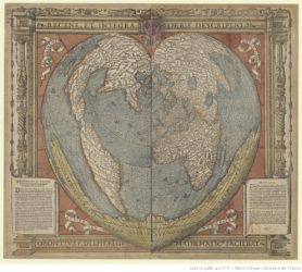
Recens et integra orbis descriptio by Orontius Finaeus. The original is in the Bibliothèque nationale de France. This image from Gallica. A high-quality reproduction can be viewed on Gallica (access by clicking this image)
It is February the 14th, and heart-shaped things seem to be everywhere. In keeping with the theme, I would like to talk about heart-shaped maps. While heart-shaped chocolates and decorations are omnipresent on Valentines day, heart-shaped maps are less often seen. Yet there are quite a few surviving from the sixteenth-century, when the cordiform (=heart-shaped) projection was first designed. Although these are not connected to the celebration of romantic love associated with February 14, recent research suggests that they may carry symbolical meaning.[Mangani 1998] They were produced in only a short period of time, from 1511 to 1566 (the dates are based on the dates of known examples).[Kish 1965: 13] We know of such maps produced by Oronce Fine (in 1519, although it does not survive), Peter Aplan (in 1530) , Gerard Mercator (in 1538) and Abraham Ortelius (in 1564). [Mangani 1998: 59; Watson 2008: 182] The earliest such map, a heart-shaped map of the world by Bernard Sylvanus, dated to 1511, was sold at auction at Sotheby’s on 14 November 2017 and a reproduction can be viewed on this page the Sotheby’s website. Whilst their appearance is striking, and the image instantly recognisable, the cordiform maps remain something of a mystery, for their mathematics, for their brief popularity, and for their meaning.
Further reading
Ruth Watson, ‘Cordiform Maps since the Sixteenth Century: The Legacy of Nineteenth-Century Classificatory Systems‘, Imago mundi 60 (2008), 182-194 (free to read online on JSTOR with registration [last checked 13 February 2020])
Giorgio Mangani, ‘Abraham Ortelius and the Hermetic Meaning of the Cordiform Projection’, Imago Mundi 50 (1998), 59-83 (on JSTOR)
George Kish, ‘The Cosmographic Heart: Cordiform Maps of the 16th Century‘, Imago Mundi 19 (1965), 13-21 (on JSTOR)
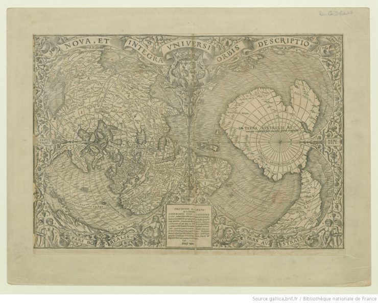
The image above is a double cordiform projection, depicting the entire world, Nova et integra universi orbis descriptio by Oronce Fine (Orontius Finacus), 1531. The original is in the Bibliothèque nationale de France. The reproduction can be viewed in detail on Gallica (can be accessed by clicking the image above).
Post by NP