Project Blog
Ubiquitous maps
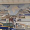
Medieval mappae mundi help us see that cartographic representations of the world are not only omnipresent but often used for purposes other than navigation. This mural painting by Peter Alma (1886-1969) in the Amsterdam Amstel train station, completed in 1939 uses its representation of the world to emphasize the global nature of the connectivity provided…
Read more
The Medieval Welsh Image of the World
The medieval view of the world in medieval Wales largely corresponded to that on the Continent, as can be seen, for instance, in the poem known as ‘Greater Song of the World’ or ‘Song of the Macrocosm’, the inhabited world is divided into three parts, as it is in T-O type mappae mundi. „Into three…
Read more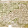
Medieval Maps: The Gough Map
Whilst the most famous medieval maps are the T-O type mappae mundi, there are other types of map surviving from the Middle Ages. A fascinating example is the Gough Map, preserved in the Bodleian Library, University of Oxford (shelfmark MS. Gough Gen. Top. 16). This map depicts the whole of the island of Britain. Like…
Read more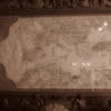
Portolan Maps
Amongst the most interesting and informative virtual exhibitions currently available is the exhibition of marine maps by Bibliothèque nationale de France. The wonderfully organised exhibition provides information on nautical maps, including an introduction to portulan charts, a guided tour, and links to the digitalised documents on Gallica, the library’s digital branch. Portolan (or portulan) charts depicting…
Read more
The International Medieval Congress in Leeds 2018
‘Big’ is the first word that comes to mind when describing the International Medieval Congress in Leeds. As a first-time participant the mere size of the event was overwhelming! Over 2000 medievalists joined together in the first week of July to discuss their new and ongoing research. Every single person walking around at the congress…
Read more
Globes and Celestial Spheres
Following on our post about the medieval awareness of the round earth, this week we look at globes. Broadly speaking, there are two types of globes one can encounter in a museum, terrestrial (depicting the Earth), and celestial (depicting the sky, the stars, and constellations). It has been famously said that there are no terrestrial…
Read more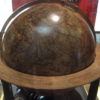
The Round Earth
The idea that in the Middle Ages the world was believed to be flat, is disproved by the many surviving medieval astronomical and geographical texts, as well as by references to the globe in literary and historical texts. The thirteenth-century French Image du monde by Gautier or Gossouin de Metz, and its Middle English translation by William…
Read moreThe Gibberish Scribe
For the Defining Europe project we are interested in how manuscripts travelled, who owned them and who might have been familiar with their contents. Signs of previous ownership are a great help in recreating the life of these manuscripts and provide information on the context in which the manuscripts have been used. However, tracing the…
Read more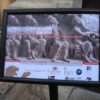
Thinking about Formulas
At the wonderful conference ‘La Formule au Moyen Âge‘ (the fourth of the name) recently concluded at the University of Poitiers Centre d’Etudes Supérieures de Civilisation Médiévale (13-15 June 2018), where I presented a paper (the slides can be accessed here) on the geographical representations of the world in the medieval encyclopaedic texts, the subject of…
Read more